Life a hundred years ago – National Heritage Week 2016

Heritage_Week_2016_GREEN-2.jpg

National Heritage Week 2016 will start on Saturday 20th August and run until Sunday 28th August. The theme this year is to celebrate a hundred years of heritage, but this can also mean celebrating life a hundred years ago. One might imagine that it would be entirely devoted to commemorating the 1916 Rising but the options are actually much broader than that.

There are a number of events in the East Cork area, including Cloyne, Castlemartyr and Youghal. Naturally Midleton will celebrate Heritage Week 2016 with FIVE events – two walking tours, two lectures and an intriguing musical recital. The events are free so do go along,. You will never know what you might learn!

Charles Street Midleton

Charles Street, now Connolly Street, Midleton, at the beginning of the twentieth century. In the background is the spire of St John the Baptist’s Church. The Potato Market was located in the yard behind the archway on the right. The granary building on the right was built to serve the former brewery which was only identified as a result of last year’s Heritage Week tour of the town! (Lawrence Collection, NLI)

Midleton Events for Heritage Week 2016 are:

Sunday 21 August, at 2.00 pm: Walking through Midleton in 1916. Meet at Midleton Library for this Walking Tour.

Thursday 28th August, at 7.30 pm: Too beautiful for Thieves and Pick-pockets. A free public lecture about Spike Island by Cal McCarthy. Venue: Midleton Library.

Saturday 27th August, at 12.00 noon. Living in Midleton a hundred years ago. A free public lecture about daily life in Midleton at the beginning of the twentieth century, given by Tony Harpur. Venue: Midleton Library.

Saturday 27th August, at 1.00 pm: What the Wild Geese heard – popular music from the 17th and 18th centuries. A FREE recital by the Hibernian Muse Early Music Ensemble. Venue: St John the Baptist’s Church..

Sunday 28th August, at 2.00 pm. Walking through Midleton in 1916. Meet at Midleton Library for this Walking Tour.

Other events in the Midleton area:-

Castlemartyr: Saturday 20th August, at 8.00 pm: John Saul, Horticulturist, from Castlemartyr to the White House. A public lecture by Conor Neligan, County Heritage Officer. Venue: Castlemartyr National School.

Cloyne: Saturday 20th August, 11.00 am to 4.30 pm: Discover Cloyne Cathedral. Including tours and guided visits. Venue: Cloyne Cathedral, Cloyne.

For further events in East Cork and elsewhere please consult:http://www.heritageweek.ie/whats-on

Markets and Fairs in early Stuart Imokilly and Barrymore.

With Cork, Youghal was the most important town in the county in 1600. It was the center of commerce in the eastern part of County Cork.

With Cork, Youghal was the most important town in the county in 1600. It was the center of commerce in the eastern part of County Cork. Its development was promoted by Richard Boyle, Earl of Cork for forty years until 1642.

One of the aspects of regional history in Ireland was the existence of Presidencies in the provinces of Munster and Connacht. These were subordinate authorities set up in the sixteenth century to impose greater governmental control over these provinces.They alleviated the burden of control placed on the Castle (the government in Dublin Castle) and allowed for more rapid response to local issues.

Shortly after the climactic Battle of Kinsale in 1601 and the ending of the Nine Year’s War in 1603, the Council of Munster (the Lord President of Munster and his chief officials) set to work on modernizing the regional economy. The key to this was the encouragement of a monetary economy based on licensed and regulated markets and fairs.  Margaret Curtis Clayton has done a splendid job of compiling the information on the markets and fairs that were newly licensed in Munster in the period 1600-1630. It should be noted that the establishment of a market or fair on someone’s property generated additional lucrative income and often enhanced an existing settlement or improved its economic prospects. The period from 1603 to 1642 was one of rapid economic change in south east Cork.

It’s worth noting that Chore Abbey (Midleton) had a market licence from 1608 renewed in 1624 – suggesting that the settlement that survived the dissolution of the Cistercian abbey was now thriving. The proximity of an annual fair in Castleredmond, first licensed in 1609, was a further boost to the local economy. In each case the licence was issued to the proprietor or landlord, who was then obliged to appoint a clerk of the market to regulate it. The proprietor also had to designate a place for the market or fair and ran a pie-powder court to settle disputes. (The name comes from the French term pied poudre, or dusty feet, for the court was a summary court conducted on the spot.) The proprietor had to pay an annual fee to the Crown for the licence and was entitled to keep the fees charged to stall-holders and the profits of justice from the pie powder court.  It is worth noting that fairs were often linked to church feastdays.

John Speed's map of Munster 1600-1611.

John Speed’s map of the province of Munster 1600-1611.

In this post our concern is the licensing of such markets and fairs in the south east Cork baronies of Imokilly and Barrymore.

Carrigtwohill: 5 Feb 1607/8. Fair – no details. Prop. David Barry, Viscount Buttevant. Renewed 1618, details lost.

Castleredmond: 24 June 1609. Fair on 3 May & 1 day following. Prop. Sir James Craig. Rent. 6s 8d Irish. Renewed, with one additional day, on 23 Dec 1624 in favour of Richard Boyle, Earl of Cork, for a rent of 6s.8d. (Note: the date 3 May was the traditional Feast of the Invention of the Holy Cross.)

Chore Abbey (Midleton): 14 Oct 1608. Market on Saturday. Prop. Sir John FitzEdmund FitzGerald. Rent: 5s English. Renewed in favour of Richard Boyle, Earl of Cork, on 23 Dec 1624, for a rent of 6s.8d.

Dangandonyvane: 25 Nov. 1606. Fair on Feast of St James (25th July) & 2 days following. Prop. Thomas FitzGerald. Rent not recorded.

Killeagh:11 July 1631. Market on Tuesday. Fairs on 1 June and 1 November each with one day following. Prop. William Supple. Rent not recorded.

Rostellan: 25 Nov. 1606. Market on Saturday. Prop. Thomas FitzGerald. Rent not recorded.

Youghal: 22 Dec 1609. Market on Wednesday and Saturday. Fairs on Eve of St Luke (18 October) & 3 days following and on the Feast of the Ascension (usually late May). Prop Youghal Corporation. Free of rent.

What is of interest are the two market days in Youghal and the two annual fairs there. Clearly Youghal was of major importance. Cork appears to have had a market every day until 1613 when a shortage of goods led to the market being restricted to Wednesday and Saturday. Also of note is the absence of any licence for a market in Cloyne, Ballinacorra, Mogeely or Ballymartyr (Castlemartyr). Nor is there any market on Great Island – the nearest one being in Carrigtwohill. The absence of a market in Cloyne suggests that Sir John FitzEdmund FitzGerald was wary of intruding on pre-existing market rights established by the bishops during the medieval period. The market in Carrigtwohill followed a tradition of markets going back to the 1200s. In respect of Chore Abbey (Midleton), it is interesting to note that Richard Boyle, Earl of Cork, succeeded Sir John FitzEdmund FitzGerald as leaseholder of both the old monastic estate, and Castleredmond. FitzGerald had died in 1612.

Reference: Margaret Curtis Clayton: ‘Early Stuart markets and fairs in Munster, c1600-1630.’ Journal of the Cork Historical and Archaeological Society, vol 115 (2010), pp 167-177.

‘A good market for flesh…..and fish.’ Heritage Week 2015 in Midleton.

https://i0.wp.com/www.heritageweek.ie/wp-content/uploads/2010/06/NHW-2015-Logo.jpg

I thought the opening words of the title would get your attention!  This year’s Heritage Week is almost upon us. Starting on Saturday 22 August and running to Sunday 30 August, Heritage Week 2015 has our industrial heritage as its theme. I’ve expanded this slightly to include Midleton’s commercial history as well as its industrial history. It should be noted that I’m including Ballinacorra in this – because we simply cannot talk about the industrial and commericial heritage of Midleton without reference to the port at Ballinacorra. I hope people will take the time to attend something during the week or, at least, visit a heritage site.

In co-operation with Midleton Public Library and MyPlace the following events have been organized in Midleton:

Sunday 23 August: Walking Tour – Discover Midleton’s Commercial and Industrial Heritage. Meet at Midleton Library, starting at 2.30 pm. Guide: Tony Harpur.

Wednesday 26 August: A good market for flesh….and fish.’ The commercial and industrial history of Midleton and Ballinacorra. 1608-1948. Public lecture in Midleton Public Library. Time: 2.00 pm. Speaker: Tony Harpur.

Thursday 27 August: A Heritage Week Extra! From Mainistir na Corann to Midleton. 1177-1670. Public lecture at MyPlace Midleton. Time: 8.00 pm sharp. Speaker: Tony Harpur.

Sunday 30 August: Walking Tour – Discover Midleton’s Commercial and Industrial Heritage. Meet at Midleton Library, starting at 2.30 pm. Guide: Tony Harpur.

Main Street, Midleton, around 1900.

The parking on Main Street, Midleton hasn’t changed much in over a hundred years!

Other events in the East Cork area worth visiting:

Saturday 22 August: Discover Cloyne Cathedral. The cathedral is open from 11.00 am to 4.00  pm. Tours: 11.30 am and 2.30 pm..Free event.

Saturday 22 August and Sunday 23 August: Mrs Kevin’s Cat! A family living history event – join the search for Mrs Kevin’s lost cat in Fota House. Time: 12.00 noon to 14.00 pm.

Sunday 23 August: Youghal Medieval Festival. Family event. Venue: St Mary’s College gardens. Time: 12.00 noon to 6.00 pm.

Wednesday 26 August: Why can’t I find my ancestors? Genealogy event in Cork County Library HQ, Carrigrohane Road, Cork. Time: 1.30 pm to 2.30 pm.   Note: one to one genealogy sessions are also available that week in the same venue. Times: Monday/Tuesday/Thursday/Friday 9.30 am to 4.30 pm. & (NB) Wednesday 9.30 pm to 12.00.*

Sunday 30 August: History Hunt in Cloyne Cathedral. Family event. Time: 2.30 pm to 5.00 pm.

Other events for National Heritage Week 2015 can be found on http://www.heritageweek.ie or on the County Heritage Service webpage: http://www.corkcoco.ie/co/pdf/609621658.pdf. You can also pick up a booklet or leaflet in any local library branch.

Going for a (long) walk on National Pilgrim Paths Day.

Pilgrim Paths Day 2015

In 1907, Canon Patrick Power, a priest of Waterford and Lismore diocese, published an interesting article in the Journal of the Royal Society of Antiquaries of Ireland entitled: The ‘Rian bo Padraig’ (The Ancient Highway of the Decies). The subject of his paper was part of the ancient route that led from Cashel in County Tipperary to Ardmore on the coast of County Waterford. Part of this route was called the Rian bo Padraigh or the ‘Path of St Patrick’s Cow.’ We shouldn’t be surprised to read that St Patrick had a cow, after all, in a previous life he had been a herdsman. Canon Power gives the local tale of how this trackway got its name:

St Patrick’s cow, accompanied by her calf, was grazing peacefully on the alluvial flats by the side of the Tar river in the extreme south of Tipperary, when the calf was abducted by a wily cattle-thief from Kilwaltermoy, or somewhere south of the Bride, in the County Waterford. The robber, with his booty, started in haste for his home some eighteen or twenty miles distant, and shortly afterwards, the cow, having discovered her loss, commenced a distracted pursuit. In her fury, as she went, she tore up the earth with her horns – hence the double trench – till she overtook the robber whom she promptly gave his deserts. 

A number of things come out in this story.

First the location of the abduction of the calf – on the very rich alluviall grasslands by the banks of the Tar river. The south of county Tipperary is known as excellent country for raising racehorses – but the same land is equally good for raising cattle, especially dairy cows. Second point: the cattle-thief rings true to the period – the national sport in ancient Ireland wasn’t hurling as the GAA would have us imagine.  Rather cattle-raiding was THE sport that everyone aspired to – after all Ireland is the only country that I know of with a cowboy story as its national epic – the Tain Bo Cualigne is all about a war started during a cattle raid. Even the Americans haven’t got a cowboy story as THEIR national epic, despite Hollywood’s best attempts. The third point is that the robber came from the area just south of Lismore, somewhere in the valley of the Bride River – another rich cattle-raising area.  But to get there the thief had to cross the Blackwater or Amhainn Mor na Mumhan (the Great River of Munster) and then the Knockmealdown Mountains.  It was a clever statagem for the route would throw off any pursuers.  Unless, of course, the pursuer happened to be a furious mother cow in search of her stolen calf. The double trench mentioned in the text refers to what Canon Power was able to observe on the ground as he spent years trying to trace the route of the cow’s pursuit of her calf – a double ditch or trench cutting across the landscape of western County Waterford.

Canon Patrick Power

Canon Patrick Power, who traced the route from Ardfinnan to Ardmore via Lismore.

What Canon Power did at the end of the nineteenth century was to trace the route of ancient pilgrims from Ardfinnan, on the Suir in south Tipperary, to Lismore, on the Blackwater in Waterford, and then on to Ardmore on the coast.  It took him years to do it, and he even managed to trace the alternative route from Lismore towards Kilwatermoy and beyond, almost to Molana Abbey, just north of Youghal. Power was able to supply his own hand-drawn maps to accompany his text and he mentioned all the local people who’d helped him in his quest to fine the route – most unusually for a scholar, but he felt he owed them much and wanted other scholars to consult the same people.

St Declan's Way

The whole walking route is now marked, and even signposted. Interesting how the distance is left off the signs!

Today the whole route is now identified as a Pilgrim Path, used by people travelling from Cashel to Ardmore or vice versa, and taking in the important monastic site of Lismore. Unfortunately it has taken us a long time to recognize the potential tourism, heritage,recreational and health benefits of these routes.  In several cases it is likely that much of the original route cannot be recovered so approximate routes are used to link up the known routes.

knockmealdown-map

Midleton is located off map some distance below the bottom left. Ardmore is located near the bottom right, also off map. The Knockmealdowns are in the middle, between Lismore on the Blackwater and Ardfinnan on the Suir.

Knockmealdowns

The Knockmealdowns can be covered by cloud because the mountains are at the meeting point of the inland airflows to the north and the sea borne weather to the south.

Saturday, 4th April (Holy Saturday or Easter Saturday, as you prefer) is National Pilgrim Paths Day – how appropriate that it happens during Easter!  My sister and I are joining walkers to follow part of the Rian bo Padraig. We’re going from Mount Mellary Abbey in County Waterford to Ardfinnan in County Tipperary on St Declan’s Way.  The eighteen mile hike will take us over the Knockmealdowns to give us a stunning view northwards over the Golden Vale in south County Tipperary.  It should take about four hours – or five for the weary and distracted!  Even the heavens are going to join in – the weather forecast looks splendid, with sunshine and warm spring temperatures (very important on top of a mountain range in Ireland!).

Mount Mellary Abbey

Mount Mellary Abbey is a Trappist (Cistercian) monastery founded as a refuge for French monks fleeing persecution in France after the July Revolution of 1830. The abbey stands on the southern side of the Knockmealdowns. The huge abbey church was built with stone removed from Mitchelstown Castle after it was burned out in 1922.

Here’s the link: http://www.pilgrimpath.ie/pilgrim-paths-day/

Ardfinnan

The village of Ardfinnan is presided over by its still inhabited castle. Note the width of the River Suir at teh foot of the castle.

One thing I’ve discussed locally is the idea of tracing the original route linking Molana Abbey to Cork by way of Cloyne – some of this route is actually known, but there are serious gaps. But I hope that one day we might be able to link St Finbarr’s Way (from Gougane Barra to Cork with St Declan’s Way and the Rian Bo Padraig via the pilgrim route through Imokilly. Such a route would allow a person to walk from Cashel to Gougane Barra via Lismore and Cloyne!

Irish-Pilgrim-Path-Marker

The Camino de Santiago has its identifiable waymarkers. So do the Irish Pilgrim Paths – this shows an ancient Irish monk carrying an early Irish crozier. Note that the monk is wearing a hood, not a pony-tail – it rains in Ireland! The Irish crozier was shorter than the Continental one – and a lot more practical – it was really a walking stick for elderly clerics, or for pilgrims!

If there’s no pilgrimage trail near you, just get out and find a nice track in the countryside to follow for a while – it’s good for the soul.

Pilgrim-Paths-Day-logo2015

.

Before Midleton – there was Ballinacorra…….

It makes no sense to discuss the early history of Midleton without considering the older, and now overshadowed,neighbour, – the village of Ballinacorra. So I’d like to examine some aspects of Ballinacorra’s history here.  I must acknowledge my debt to Paul MacCotter, who, as an excellent medieval historian, has presented so many insights into the history of the area around Midleton and Cloyne.

Ballinacurra Main Street

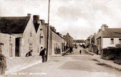
The Main Street of Ballinacorra around 1900. The building on the left might stand on the site of the mill recorded in 1301. The modern village looks very much as if it had been planned, and perhaps it was redeveloped in the later 1700s. Flowing under the road in the foreground is a culverted stream.

The village of Ballinacorra still retains its own identity despite being considered by many to be simply a suburb of Midleton. It is far enough away from Main Steet in Midleton to treat the larger town as an interloper.  In the decades since the 1960s, the main road from Midleton to Ballinacorra has  become built up, especially on the west side from Lakeview filling station (that’s a gas station to you Yanks!) to the Dark Road (‘dark’ because it was heavily shaded by trees). The eastern side of the road had just Lakeview Terrace and a couple of houses, along with Lakeview House itself. There were fields between the Presentation Convent boundary wall, which marked the southern end of Midleton town, and Lakeview filling station, and there are still fields on the eastern side between Lakeview House and the other houses on that side of the road.  However, the building of ‘The Cotswolds’ (!) and ‘Castleredmond’ housing estates has filled in some of the open space.  Charleston House still stands proudly isolated behind its high wall, trees and mercifully green fields on the western side of the road, directly opposite the entrance to the Castleredmond estate. Should the demand for housing boom again, it is likely that all the land bordering this road will be built up.

Aerial view Castleredmond

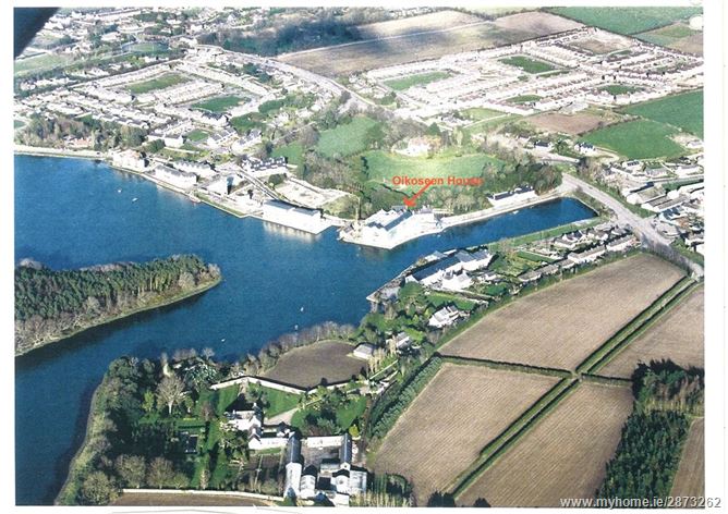
Ballinacorra Creek runs from the bottom left to the center right. The sharp straight end of the creek is the modern road from Midleton to Whitegate, cutting Ballincorra village off from its waterfront. The village proper lies byond the white line of the road. Ballinacorra house, with its adjacent farm buildings, lies at the bottom of the picture next to the creek. The strange bent wall visible at the bottom of the ploughed field, just above Ballinacorra House, draws the eye to the site of the medieval church, and the trees which surround and cover the mound that marks the Anglo-Norman motte or earthwork castle – Castranachore. The waterway coming in from the upper left is the estuary of the Owenacurra River, which flows through Midleton.

One important change in the road between Midleton and Ballinacorra was the rebuilding of that road since the 1950s – which entailed by-passing Ballinacorra and even filling in part of the waterfront thus cutting the village off from Ballinacorra Creek. This waterfront and its quays were the reason for the village’s whole existence in the first place.  During the building of the Whitegate Oil Refinery in the 1950s, it was realised that the old road was inadequate and a narrow turn in the road at the top of the Main Street in Ballinacorra to Whitegate made it difficult to get large vehicles through the village.  The solution therefore was to widen the road from Midleton to Whitegate, and it was necessary to by-pass Ballinacorra because the narrow Main Street was too constricted.  Thus Ballinacorra became one of the first villages in Ireland to be by-passed. Today, when driving from Midleton to Whitegate on the R630, it is easy for the motorist to overlook the existence of the village because the road was laid out on a raised embankment which filled the eastern end of Ballinacurra Creek.  This causeway was necessary because the road had to drop down a steep slope from Castleredmond, cross the Creek, and climb up the steep slope on the other side leading into Ballinacorra townland and continuing to Whitegate.  In effect, Ballinacorra became lost in a hole, as well as being cut off from its historic waterfront by this wide, busy road and fast traffic. You get a better idea of the difficulties posed for the engineers when you turn off the main road into the village itself and drive up the Main Street to rejoin the main road further on.

As mentioned in my previous post, Ballinacorra is a much older settlement than Midleton.  It was certainly extant in the middle of the twelfth century, and perhaps earlier. By 1160, the parish had been created as part of the organisation of the newly re-established diocese of Cloyne, the cathedral of which was just a few miles away (literally in the next parish!).  It is likely that, as with Ballycotton, the site at Ballinacorra was developed as a port for Cloyne – indeed Ballinacorra was a much more secure port for shipping. Despite being located about nine nautical miles from the sea, Ballinacorra’s sheltered position, its proximity to Cloyne (compared with Ballycotton) and its access to the rich grain growing lands of the vale of Imokilly, made it a good spot for a port. The land may have been controlled by the Ui Mac Tire family – a bunch of parvenues who had recently usurped older ruling families to take over as the local lords of Ui Mo Caille or Imokilly.  Imokilly is now a barony stretching from Midleton to Youghal and southwards to the sea.  In the twelfth century only the western part of the modern barony from the present day Castlemartyr/Mogeely (& Ballymacoda?) line to Midleton and the eastern shore of Cork Harbour was called Imokilly, but it was later expanded to Youghal. Originally the barony included the territory stretching towards Carrigtohill, but these lands were incorporated into Barrymore well before 1500. Th original lands of Imokilly seem to have been controlled by the Ui Mac Tire in the north and the Bishop of Cloyne in the south.

The Ui Mac Tire were closely allied to the MacCarthy dynasty who ruled the kingdom of Cork or Desmond (South Munster). Indeed it likely that the MacCarthys re-established the diocese that had been extinguished at Rath Breasail. in 1111. They also seem to have been closely linked to the church reforms that had been in progress since 1111.  Perhaps Cormac MacCarthy, the man who built Cormac’s Chapel on the Rock of Cashel, was the re-founder of the modern diocese of Cloyne! The MacCarthy kings were closely linked to the church reforms that were in progress in twelfth century Ireland, and their close allies the Ui Mac Tire may have followed suit.  There’s an interesting German connection here that will be addressed in a later post!

The parish of Ballinacorra covered much of the area that was later covered by the civil parish of Midleton.  A civil parish is effectively the medieval parish; today the civil parish provides the basis of Church of Ireland parish unions and is also of Roman Catholic parishes, although Catholic parishes might be drawn up to ignore civil parish boundaries.  However, in 1180, the large parish of Ballinacorra was divided in two. The northern portion of the parish was given over as a separate parish to the Cistercians who settled at Chore on the site of today’s Midleton town. The southern portion of the original parish remained as the parish of Ballinacorra or, as it later bacame, Castranachore – a name still applied to the whole civil parish in the Tithe Applotment Book of 1833.  We know that Ballinacorra was established before the arrival of the Anglo-Normans in the area in 1177 because the parish church was dedicated to St Colman of Cloyne.  This dedication to a native Irish saint invariably indicates a pre-Norman foundation.  In this case it also suggests an older direct link to the monastery of Cloyne, which had become the Cathedral of Cloyne.

Ballinacorra Church West front

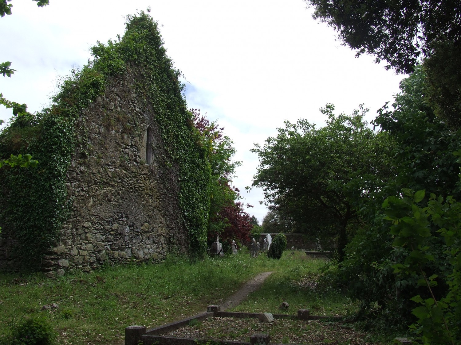
The west end of the ruined church at Ballinacorra. This view shows the typical later medieval west end of an Irish parish church – there’s no door, for that is on the south side of the church. The image is taken from the edge of the churchyard overlooking Ballinacorra Creek. The church is right on the water’s edge.

The location of the medieval church in Ballinacorra, right on the southern shore of Ballinacorra Creek, strongly suggests that Ballinacorra was envisaged as a port for both the town of Cloyne, and for the Mac Tire lands.  The grain grown in Imokilly could easily be transported to Cork by boat or ship from Ballinacorra – a trade that continued into the twentieth century.  It might be thought that Youghal would have been the principal port for the area, but the dedication of that parish to St Mary suggests that Youghal is a later foundation of the Anglo-Normans.

In 1177, King Henry II gave two of the original leaders of the Anglo-Norman expeditionary party in Ireland the right to seize the kingdom of Cork.  This broke the Treaty of Windsor which had divided Ireland between a territory under Henry and the rest of the country under Rory O’Connor, the so called ‘High King’ of the Irish.  The two men given this license were Robert FitzStephen and Milo de Cogan.  These ruthless men promptly swooped into Cork – with the land of Imokilly being the first to fall victim to their raid.  FitzStephen claimed Imokilly and Olethan.  He subdivided much of the land into smaller estates for his knights. These knights then rented out the land to smaller tenants – in some cases they left the lands in the hands of the Irish families that had originally claimed it, as long as they paid rent to their new landlords.  This was done because there seem to have been insufficient Anglo-Norman tenants to go around.  Robert FitzStephen had granted much of Uflanethe (the plain between Midleton and Castlemartyr/Mogeely) to the father and son team of Robert and Thomas des Autres. It is uncertain if the des Autres were the new landlords to the Mac Tire family of if FitzStephen was their immediate landlord.  Whatever it way the arrangement was worked out, the Mac Tire still occupied Mogeely and held what is now Midleton, with Castleredmond, the two Broomfield townlands, and Killenamanagh near Mogeely.  The des Autres continued to hold lands in Imokilly throughout the medieval period, but in increasingly smaller holdings.  This family is most likely the modern Waters and probably the Salter family that can be found in East Cork today.  Indeed Paul MacCotter suggests that they give their name to several townlands, including of Ballintotis – the former Balyogy became Baile an tAiteirs (des Autres town) perhaps from the family’s possession of Ballintotis in the fourteenth century.

The des Autres may have established their caput, or seat, at Ballincorra by building an earth and timber castle there.  Thus Ballinacorra became Castlecor or Caislean na Cora.  This earth and timber castle may represented by the unexcavated tree-covered mound in the grounds of Ballinacorra House.  This steep mound is located just yards from the medieval church – the relationship suggests a classic example of Anglo-Norman manorial practice: church and castle (or manor house) being set side by side.  The location of the medieval village is unknown, but most likely it was on the site of the present village.  It is even possible that the village was originally on the site of Ballinacorra House but the building of the castle meant that the inhabitants were forced to move to the site of the modern village.  This high-handed behaviour was common enough among the Anglo-Norman elite.

Ballinacorra Graveyard

The eighteenth century wall separating Ballinacorra House from the old churchyard. The trees mark the site of the still extant mound, which appears to be the motte of the early Anglo-Norman castle that gave the village its other name – Castle Cor or Castranacore. The proximity of the castle to the church was typical of the Anglo Normans. It is possible that the original village was moved east to its present site when the castle was established on this site.

This type of high-handed behaviour may have precipitated the foundation of the Abbey of St Mary of Chore (Midleton) in 1180 by Mac Tire and the Bishop of Cloyne (perhaps with encouragement from the MacCarthys).  By handing some of their property to the Cistercians, the Mac Tire kept it out of the hands of the Anglo-Normans.      .

In a deed that is hardly later than 1183, Robert des Autres granted the tithes of three churches in his lands to St Thomas’s Augustinian Abbey in Dublin.  One of these grants was ‘the great church of Castello de Cor.’ No, this referred not to a place in Italy but to the church at Ballinacorra (or Castlecor as it was now called).  Note the name of this castle – it will come up, and cause trouble, in a later post!

In 1182 a party of Anglo-Norman knights travelling from Cork to Waterford stopped off for the night at Mac Tire’s house in Mogeely – and were murdered. This incident sparked off a widespread revolt against the Anglo-Normans in Cork and the MacCarthy king, Diarmaid, launched a massive attack on Imokilly.  All the castles of Imokilly were destroyed – including Castlecor.  This revolt was suppressed by Raymond le Gros in 1183, but the Mac Tire and MacCarthys continued to fight a guerilla war until about 1220.  All this suggests that the initial Anglo-Norman settlement was rather weak and that the new estates must have suffered from the conflict.  Perhaps the des Autiers suffered severe damage to their properties during the revolt and its suppression as well as ongoing troubles into the early 1200s.

Sailing route to Ballinacorra

The sailing route from the lower part of Cork Harbour to Ballinacorra follows the yellow line via East Ferry to the green dot which marks the Creek of Ballinacorra. The total distance to Roche’s Point and the open sea is about 9 nautical miles. (Image from sailcork.com)

With Robert FitzStephen’s death in 1183, his estates were inherited by his nephew Raymond le Gros, the same man who had suppressed the Mac Tire/MacCarthy revolt that year.It isn’t certain when Raymond died, but it was sometime between 1185 and 1198.  Raymond’s lands were inherited by his nephew, Richard de Carew. Since we know that Thomas des Autres sold the vill and castle of Cor (Ballinacorra) to Richard de Carew in the 1190s, we can surmise that Raymond was probably dead by the middle of that decade.

The status of Castranachore/Caislean na Cora/Castle Cor/Castle Corth now changed as de Carew made it the caput or capital of his large manor which seemed to correspond to the old territory of Uflanethe.  This manor stretched from near Carrigtohill in the west almost to Killeagh in the east with a portion reaching the sea at Garryvoe and Ballycrenane in the south east.  From north to south, the manor reached from Dangan to the northern outskirts of Cloyne. The manor of Castlecorth also included the eastern portion of Great Island (Templerobin parish?) and a larger detached portion around Aghada, where the original caput seems to have been located by Robert FizStephen.

Being at the center of the manor, Ballinacorra (or Castlecorth, as it was called) was a busy market town and very useful port. This was effectively the most important town in Imokilly along with Cloyne and the newly developed port of Youghal.  Later medieval documents show that, by 1301, there was a watermill in the town (perhaps on the stream that flows into the creek). There also seems to have been a leper hospital in the vicinity of Castlecorth – but no remains are extant today.

To inhabit their new capital, the Carews seem to have brought in settlers from elsewhere – particularly from south Wexford. It is interesting to note that Robert FitzStephen was awarded a half-share of two cantreds or baronies in south County Wexford by Dermot MacMurrough.  These were the baronies of Bargy and Forth on the south coast of the county (indeed on the extreme south east corner of Ireland – the point of Ireland nearest to Pembrokeshire, whence came the original Anglo-Norman forces. Families with names like Walsh, Burgess, Coppinger, Tanner, Dene, Cod, Field, Fleming, Marshall, Mynes and even Harpur all settled in Ballinacorra from 1220. The names of these settlers were remarkably similar to the names of the Anglo-Norman settlers in Bargy and Forth – almost certainly they were all related, perhaps younger sons in search of more opportunity.  Paul MacCotter, who has had a chance to study some of these names, is very clear that this is a very close relationship between the families settled in south Wexford and in Imokilly, a relationship that deserves further exploration, especially since the Carews also inherited Robert FitzStephen’s property in Wexford.

Events in the fourteenth century brought about some serious changes in Ballinacorra/Castlecorth.  Firstly, a strong Gaelic revival led by the MacCarthys meant that Thomas Carew, sixth lord of Castlecorth after Raymond de Carew, lost much of his valuable estates in West Cork. In 1339 he sold the Burgary (town) of Castlecorth to William de Barry, the brother of David Barry, the lord of Barrymore.  The result of this was that Ballinacorra/Castlecorth ended up in Barrymore barony until the later 1600s or early 1700s.  This didn’t just mean the village or town of Ballinacorra, it also included the three townlands of Ballinacorra (town/East/West), the two Bawnards (East/West), and Loughatalia. To make matters worse, Thomas Carew was attainted for treason in 1340 and his manor of Castlecorth was confiscated by the government, although it was reluctantly allowed to remain under the tenuous control of the Carews of Garryvoe.  The separation of the vill or town of Ballinacorra/Castlecorth from the manor of Castlecorth was disastrous.  The port still functioned, but the town was no longer the center of economic activity in the western part of Imokilly.  In the following century as the FitzGeralds re-established themselves in Imokilly, the focus seems to have shifted to the newer town of Castlemartyr.

Bennett's maltings

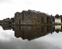
The grainstore built by Anderson and Lapp in the late 1700s and later acquired by John H Bennett & Co, maltsters. This image shows the buildings before they were converted into apartments. The lovely still water shows what the creek looks like at high tide. Sadly Ballinacorra Creek was allowed to silt up in the twentieth century and eventually closed as a port in the 1960s.

Paul MacCotter reckons that Ballinacorra had declined by the seventeenth century to a small village, but it had one more shot at glory as a result of the Reformation – the parish was reunited with its northern portion in the early seventeenth century.  The suppression of the Cistercian abbey at Chore (Midleton) by Henry VIII eventually led to the two parishes becoming one, thus the name Castranachore rather than Corabbey for the parish of Midleton in the Tithe Applotment Book in 1833.  In the later 1600s Colonel Richard FitzEdmund FitzGerald, the heir to the Seneschal of Imokilly, moved to Ballinacorra, having failed to regain his ancient seat of Castlemartyr.  He probably lived in Ballinacorra House, which is certainly the oldest continuously inhabited house in the parish of Midleton. At present it appears to be an eighteenth century modification of a seventeenth century house, but one wonders if it actually is a reworking of a later medieval tower house or small castle?  Eighteenth century Ballinacorra was divided between the Longfields of Castlemary (near Cloyne) and the Boyles, Earls of Shannon, who lived at Castlemartyr.  At one point the brother of George Berkeley, Bishop of Cloyne,

Edward Bransfield RN

Edward Bransfield RN was born in Ballinacorra about 1785, and was press-ganged into the Royal Navy in 1803. Unusually, for a Catholic, he did well for himself, rising through the ranks, becoming a noted early explorer of the Antarctic. Very likely his hedge-school education equipped him to take advantage of any opportunities that presented themselves to him, unlike most impressed men at the time.

It would seem that Ballinacorra (as we must now call it) revived in the later 1700s, when Anderson and Lapp, two Cork merchants built quays and grain stores on Ballinacorra Creek.  Later the malting of barley became the most important industry there, supplying malted barley to several breweries, including the Guinness brewery at St James’s Gate in Dublin.   By then however, the creation of the borough of Midleton in 1670 meant that the northern neighbour overshadowed the village of Ballinacorra.  In 1803, a young fisherman called Edward Bransfield was press-ganged from his father’s fishing boat into the Royal Navy.  The young man remained in the navy after the final defeat of Napoleon in 1815, spending his time exploring the Southern Ocean and the shores of Antarctica as well as the South Shetland Islands, which he claimed for King George III (who actually had died the day before!). Sadly, the port at Ballinacorra was finally closed in the 1960s, thus ending centuries of international trade from the Creek of Ballinacorra.

Decade of Bicentenaries? New churches expressing Irish Catholic hopes after 1800.

Interior Shanagarry church.

The intimate interior of Shanagarry church. It seems likely that this church originally ended in a blank wall with the altar in front of it, the arch and chancel being added later as funds were raised. The roof was originally an open timber structure.

We in Ireland are currently involved in the Decade of Centenaries – an all-Ireland initiative to commemorate the events that happened in Ireland from 1912 to 1922. The events being commemorated include the Home Rule Bill of 1912, the foundation of the Ulster and Irish Volunteers, the outbreak and course of World War I, the Easter Rising, the partition of Ireland into two political units, the War of Independence (Troubles), and the Anglo Irish Treaty of 1921, with the arrival of effective dominion status in the Irish Free State in 1922.

But I wonder if we have also forgotten to look back a further century to the early 1800s.  In 1801 the Irish Parliament ceased to exist and a smaller group of MPs had to speak for Ireland in the Westminster Parliament. Hopes were raised during the run-up to the Act of Union that Catholics would be given political rights – a natural follow through of the gradual removal of restrictions on Catholic worship, land ownership, education, and entry to both the legal and medical professions.

What Catholics wanted was the right to be represented on the local government bodies, to become magistrates and to stand for election to Parliament.  Furthermore, the fact that Britain (and, therefore, Ireland) was involved in a major war against Napoleon’s French Empire weighed heavily on the minds of political figures in both Britain and Ireland.  How could the Crown ensure the loyalty of Irish Catholics, who until the French Revolution had looked to France for support?  One way was to bring the Catholic clergy onside.  The savage violence of the Revolutionaries in France against the Church had already alarmed the clergy in Ireland.  Cleverly, the (Protestant) government in Ireland (with the support of the British government) had founded a seminary for the education of catholic clergy and laymen in Maynooth in 1795, supporting it with an annual grant.  The effect was gratifyingly immediate for the government – the Catholic hierarchy condemned the 1798 Rebellions and supported the Act of Union in 1800.

The prospect of Catholic Emancipation reached fever pitch by 1815 – but somehow the government found reason to go back on its promises until Daniel O’Connell threw down the gauntlet in 1828.  Meanwhile Catholics in Ireland felt they could do something for themselves about their standing in the community – they began to either rebuild their chapels or build many more new chapels to cater for a rapidly increasing population.

Cratloe Church

The tiny country church of Cratloe in County Clare, perfectly preserved and beautifully restored. A rare national treasure by any standard, and a very rare survival. It was begun in 1791 (nave and chancel) and extended in 1806 (transepts, seen here) and incorporates a medieval doorway brought from elsewhere. Daniel O’Connell gave a speech to crowd here during his 1828 election campaign.

Cratloe Gallery

The interior of Cratloe Church shows the simple design with open timber roof and galleries. The T-shaped plan of Cratloe allowed for the installation of THREE galleries! They were a nightmare to restore given that people are much taller now. Such interiors were usually heavily embellished later in the nineteenth century.

In 1808, Dr John Milner, Catholic Vicar Apostolic of the Midland District in England (effectively Catholic Bishop of Birmingham), visited Ireland for the opening of St Anne’s and St Mary’s Church in Shandon – now the North Cathedral in Cork (the south Cathedral is St Fin Barre’s Anglican Cathedral by William Burges).  Milner was an early advocate of the gothic revival style in church architecture for Catholics deeming it an original Catholic style.  Now a fine church had been built in Youghal in the 1796.  This showed early gothic revival features like pointed arches, but it also included a very ‘Protestant’ feature – galleries going around three sides of the interior.  The galleries were necessary to accommodate an increasing population.  Youghal boasted the finest Catholic church in the diocese of Cloyne for many decades thereafter.

St Mary's Catholic Church Youghal

St Mary’s Catholic Church in Youghal founded 1796 as the finest Catholic church in the diocese of Cloyne. Only a few hundred yards from the Anglican St Mary’s Collegiate Church, which is a medieval foundation. The tower seen here was apparantly once topped by a spire of timber and lead, but it blew down in a storm.

St Mary's Catholic Church interior

The interior of St Mary’s in Youghal showing early Gothic revival pointed arches and the galleries which give the place the atmosphere of a Wren church in London, or a Congregational church in New England.

The church in Youghal was an exception.  Smaller communities were also replacing run-down chapels.  This year, 2014, saw two bicentenaries celebrated in neighbouring parishes.  The small village of Ladysbridge is part of the parish of Ballymacoda and Ladysbridge.  In 1814, the Catholics were given land by the Protestant Henry Boyle, 3rd Earl of Shannon, who lived nearby in Castlemartyr House (now a luxury hotel!).  Lord Shannon’s gift of land and funds was to facilitate the provision of a place of worship for Catholics in Ladysbridge. A generous landlord could be a boost to the local Catholics but a difficult landlord could be very troublesome indeed.  In Midleton the landlord refused to allow the building of a Catholic chapel within the town until the 1890s!

The design of Youghal church seems to have been used as a template for Ladysbridge church for there were galleries on three sides of the interior.  The simple basic design was typical of the type of church that Catholics were building at this period – the urgent need was for solid structures to accommodate a rapidly increasing population, decorative embellishment was a secondary consideration.

ladysbridgechurch

The simple shape of Ladysbridge church is typical of the type of architecture used before the Famine in Ireland. However the walls and gables were raised a few feet in the 1958 refurbishment. There was once an external staircase leading to the internal gallery.

Following a visitation in 1828, Bishop Michael Collins (no, not THAT Michael Collins!) left a description of Ladysbridge church.  He said it measured ’80 by 36 feet’, and that it was ‘commodious well built and covered with Welsh slate, (some chapels still had thatch it seems).  The church had ‘an excellent and tasteful altar and a well-executed gallery,’ and it only lacked one detail: ‘it wants only to be ceiled’ – which proves that the roof was of open work timber at the time.  The bishop summarised that Ladys Bridge (as he called it) was ‘the best country chapel I have seen in the Diocese of Cloyne hitherto.’


Ladysbridge interior

The 1958 renovations stripped Ladysbridge church of the side galleries. The three altars and mosaic shown in the picture were all products of the 1958 refurbishment. The original decoration was much simpler, and the roof was of open timber work.

In those days, the parish of Ballymacoda and Ladysbridge included the village of Shanagarry.  This was a place with associations to William Penn, founder of Pennsylvania.  In 1814, Fr O’Neill managed to acquire land there to build a second church, which still survives with little alteration.  Fortunately O’Neill already had a functioning chapel in Ballymacoda.  In the 1830s the old civil parish of Kilmahon (Shanagarry) was transferred from the parish of Ballymacoda and Ladysbridge to the parish of Cloyne.

Shanagarry Church

Shanagarry church is much closer to the original appearance of Ladysbridge. Indeed the two churches may have been built by the same team of craftsmen.

The irony of the situation is that the Parish Priest of Ballymacoda, Ladysbridge and Shanagarry was Fr Peter O’Neill, a man who had been tried, condemned and whipped in Youghal for concealing information on subversion from the authorities.  He may or may not have been given this information in confession.  Shipped off to New South Wales and Norfolk Island, O’Neill was only the third Catholic priest to inhabit Australia.  However he was rapidly reprieved by a worried and embarrassed government – they needed the clergy to calm an angry Catholic populace.  It is possible that Lord Shannon was trying to placate his Catholic tenantry by offering land for building a chapel.  In the late 1950s the church in Ladysbridge was heavily rebuilt and redecorated.

Today, Saturday 29th November 2014, the neighbouring parish of Cloyne begins the celebrations of the building of its Catholic church in 1815.  This building still functions, although it underwent several changes.  The interior seems to be a design by Michael O’Riordan, an architect who became a Presentation Brother in Cork.  O’Riordan designed several churches in the dioceses of Cork, Cloyne and Ross.

St Colman's Church, Cloyne

Sadly, the original exterior of Cloyne church was severely ‘modernised’ in the late 20th century, giving it a very bizarre appearance indeed.

Cloyne church repainted interior

The gothic revival exterior of Cloyne hides a fine classical interior  The reredos motif seen here seems to be the work of Brother Michael O’Riordan – seemingly a reworking of the 1830s. Exactly the same motif was used in nearby Ballintotis church.

It has been estimated that between 1800 and 1850 (more accurately 1796 and 1846) about a hundred churches and chapels were rebuilt or newly built in the mostly rural diocese of Cloyne  Surely a testament to the strong religious devotion of the Catholics of the period.  Most of these churches were quite small ,including the now vanished chapel of St John in Midleton in this.  Several of these buildings were replaced after 1850 in a more convincing gothic revival style, although Midleton had to wait until 1894-96 for a huge new church to be constructed.

Part of the Catholic revival at the period included the provision of proper parish registers.  Parish registers were already in use for several decades from the middle of the eighteenth century, but many were judged to be inadequate during later episcopal visitations (essentially inspections by the bishop).  Older registers often contained baptisms, marriages and sometime burials all mixed up together in the same volume.  It seems that most of the older registers were lost or even discarded when new registers were introduced. Also bear in mind that the storage conditions for such registers was often poor until decent churches were built. As you can imagine, the losses of the older registers remains a source of deep regret to Irish genealogists.

Further reading on Amazon.com

Ireland Before the Famine: 1798-1848

King Dan: The Rise of Daniel O’Connell 1775 – 1829

The Decade of Centenaries can be followed here: http://www.decadeofcentenaries.com/

Note: I used the word chapel instead of church to describe Catholic places of worship before 1850 because that was the general use at the time, and because few of them had a cemetery attached, churches were in the hands of the Established Anglican Church of Ireland, and these usually had a collegiate cemetery attached for use by the whole population.