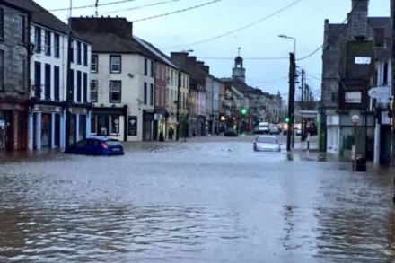
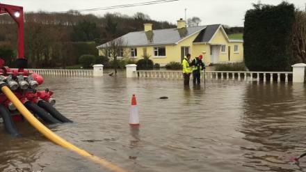
The from Lewis Bridge of the flooded southern end of Main Street, Midleton, on Wednesday morning, 30th December. (Irish Examiner)
Walking by the banks of the Owenacurra River, the principal river on which Midleton stands, I have noticed in recent weeks that even the family of ducks which frequent the place have now flown. Only the herons are still in residence. That’s how serious the rainfall has been since November, exacerbated by the sudden flooding of parts of Midleton on the night of Tuesday 29th December and on the morning of Wednesday 30th December 2015. However, the history of flooding in Midleton goes much further back – it’s a reality of the town that simply hasn’t been properly addressed.
One of the best early descriptions of flooding in Midleton is that from 1895: this flood happened on a Saturday night/Sunday morning and saw the Owenacurra River overflow its banks between Ballyedmond and Ballinacurra. ‘…all the low lying lands…are deeply flooded to a greater extent and depth than has been seen before by the oldest inhabitant.’ So severe was the flooding that the streets and sidewalks (the original word in the text) were ‘.…deeply submerged during the day causing much inconvenience to pedestrians going to and returning from their respective places of worship, many of them having to employ cars to convey them over the flooded portions of the town.‘
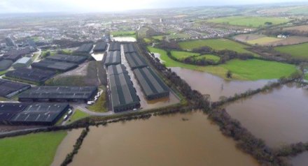
View over the flooded area of the distillery (mid-ground) towards the west. The disused railway line to Youghal is represented by the double of row of trees on the right. The flooded rugby club is just above the distillery. (Irish Examiner)
In 1911 another flood proved, perhaps, more devastating, because it happened on a Saturday, a busy market day: the flooding was caused by a massive thunderstorm lasting from about 10.30 am to about 3.30 pm accompanied by flashing lightning that terrified both the people of the town and draft animals.The worst of the storm happened between 12.00 noon and 1.30 pm. The deluge proved so bad that vehicular traffic had difficulty making its way through the town. The lower end of the Main Street was several inches deep in water and ‘…presented the appearance of initiating a lake.’ The lower part of Thomas Street was inundated to a depth of three feet and cellars on Main Street began to fill with water.
The flash flooding of 1920 left many homes deluged and even threatened the lives of animals who had gone into the Owenacurra or Roxborough rivers. The depth of the flooding reach some five or six feet The lower part of Thomas Street was inundated to a depth of three feet, with seven or eight houses being abandoned as the inhabitants sought refuge elsewhere. The cellars on Main Street began to fill with water.
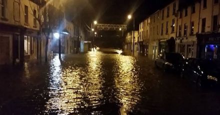
The onset of the flooding on Main Street, Midleton, on the night of Tuesday 29th December. (Irish Mirror)
What is too frequently forgotten is that the centre of Midleton is a low lying area between two rivers – the Owenacurra on the west and the Roxborough/Dungourney River on the south. Although the land between these rivers is not entirely flat (indeed there is an outcrop of rock at one point) most of it is quite flat, but deceptive. Midleton is usually, but incompletely, described as being on the Owenacurra River, but the more dangerous river is almost certainly the Roxborough. This is the river that has flooded the lower end of Main Street frequently in recent years. The trouble with the Roxborough is that it is barely noticeable in the town – people just drive over Lewis Bridge to and from Main Street, not realizing that the river below the bridge is a strongly flowing stream that can flood very rapidly. The Roxborough is fed not only by its main stream coming from Dungourney but also by a watercourse coming from Loughaderra and Ballybutler in the east, near Castlemartyr.
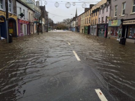
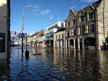
View down the flooded southern end of Main Street, Midleton, on Wednesday 30th December 2015. Note the ripples caused by a strong southerly wind blowing the water up the street. (Irish Examiner)
There is an opinion that the railway line that was built to link Midleton and Youghal to Cork in 1858-1860 may actually follow an original ancient dried up course of the Roxborough/Dungourney River just to the north of the town. This was the area that was badly flooded on 29th and 30th December 2015, as was part of the modern distillery, and the areas along the Dungourney Road, including the Rugby Club (the latter being under several feet of water) and several houses. The route of the railway line runs directly alongside these sites.
The trouble with the Owenacurra is that it reaches a pinch-point where the Cork Road Bridge stands. There is a ridge of higher ground bringing the Cork Road into Midleton with a corresponding area of somewhat raised land on the other side around the courthouse. This can lead to the floodwater in the Owenacurra backing up on the northern side of the bridge. To complicate matters, several houses were built very close to the river in the latter years of the twentieth century, often on low ground.
The background to all this is the almost persistent rain since early November (seven storms in eight weeks, with more rainfall in between) adding up to a record rainfall for the month of December – indeed the rainfall in December alone was the equivalent of THREE MONTHS of winter rainfall! The two rivers and their tributary streams were full to saturation and almost contantly in full spate. The exceptionally high tides coming in from the sea, as well as a strong southerly wind all contributed to the conditions for a perfect storm leading to a flood. The arrival of Storm Frank on the 29th December was the spark that led to disaster. The two rivers burst their banks – but, fortunately, the Roxborough/Dungourney didn’t completely burst its banks – that would have been a true catastrophe.
The N25 linking Cork to Waterford and Rosslare flooded between Castlemartyr and Killeagh. The flood was so bad that it took a week of pumping to clear the road for traffic. (Evening Echo)
No warning was given by the County Council of an immanent flood threat. The flooding started during the night of 29th and rapidly became very serious indeed. Families were evacuated from their homes in several areas and one family was rescued from a car trapped between two flooding streets. The Defence Forces were called upon to use their high-axle trucks to drive through the floods to rescue people. The Midleton Park Hotel, Midleton College and the Castlemartyr Resort Hotel all accommodated evacuated families. Meanwhile the waters were spreading. It was the combined efforts of volunteers, property owners, business owners and the small local council staff that prevent even more properties from flooding. The southern end of Main Street was closed for most of Wednesday 30th, being opened around 6.00 pm. It is extraordinary that not a single life was lost, despite some houses on the Mill Road being situated below road level! One observer said that she had lived in Midleton for 84 years and never saw a flood like it.
The 2015 flooding wasn’t just confined to Midleton – parts of Castlemartyr were flooded, as well as Glanmire and Glounthaune. Many local roads were rendered impassable by floods, and the N25 (or Euroroute 1), the main road from Cork to Waterford, was actually closed between Castlemartyr and Killeagh due to a local turlough (a seasonal lake) spreading its waters over a mile of the road. It took a week of pumping to clear the N25 for traffic again. As the flooding has receded people discovered that several of their local roads are now barely passable, if not entirely ruined. The road linking Lisgoold to Midleton and that linking Midleton to Dungourney are in a particularly poor condition.
Councillor Susan McCarthy’s photo of the flood on Main Street, Midleton, on the morning of 30th December. The fine stone building across the street is the Pugin building, formerly the Midleton Arms Hotel and more recently McDaid’s Pub. Refurbishment started before Christmas and is still ongoing, although the ground floor got flooded on this occasion. (Councillor Susan McCarthy)
One thing that did emerge was the community spirit – farmer brought in their tractors and tankers to suck up the waters from flooded houses and business premises, and to remove the flood from Main Street, Brodrick Street and other parts of the town. Irish Distillers used their equipment to assist properties on the Dungourney Road whilst clearing the floodwaters from their own property. Many shopkeepers reopened as soon as they could, often within a day of the flooding.
The reality is that Midleton was actually fortunate that matters were not worse than they turned out to be. This is of no comfort to the people evacuated from their flooded homes, or to businesspeople who are still picking up the pieces. Some thirty or so families were evacuated or had to abandon their homes and some forty businesses suffered, some being flooded for the first time ever. Yet, compared with the people living along the banks of the Shannon River (who have been inundated from the middle of December at the latest) and in Bandon (who were flooded twice), Midleton got off relatively lightly.
Regrettably, Midleton IS historically prone to flooding, but thankfully it usually affects just one or two localized parts of the town. The flooding of December 2015 was a severe shock – the lack of warning, the extent of the damage, the closure and even destruction of local roads was a real wake-up call to the people of Midleton. We have to do something about the matter. Hopefully something will come of the public meeting at the Midleton Park Hotel on Tuesday 12th January at 6.30 pm.
